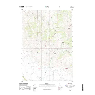
2020 Map of Ennis Gulch
USGS Topo · Published 2020About this map
Fred and Mary Draw sits within a high-elevation drainage system where the Salmon National Forest meets the Challis National Forest at the Lemhi and Custer County line. This landscape is defined by the steep descent of the Lemhi Range, characterized by narrow corridors like Black Canyon and the expansive Ennis Gulch. The hydrography is particularly complex, featuring a network of tributaries including Poison Cow Creek, Little Morgan-Cow Creek, and N Fork Morgan Cr that feed into the valley floor. Toward the southern extent of the map, the terrain levels out near Pahsimeroi Rd and Old Hwy, indicating the transition into more accessible ranching or transit land. This area serves as a significant intersection of federal forest lands and local landmarks such as Red Point and the high-altitude Goat Lake.
Find a feature on this map
31 named features on this map. Tap any name to fly to it.
Don’t see what you’re looking for? This feature index may not catch every label — zoom into the map to look around manually.
Map Details
Editions of this 2020 Ennis Gulch Map
This is the sole edition of this map. No revisions or reprints were ever made.
Other maps of this area

1955 · Dubois
USGS Topo · 1:250,000

1956 · May
USGS Topo · 1:62,500

1956 · Challis
USGS Topo · 1:62,500

1957 · Challis
USGS Topo · 1:250,000

1958 · Dubois
USGS Topo · 1:250,000

1960 · Challis
USGS Topo · 1:250,000
1962 · Allison Creek
USGS Topo · 1:24,000
1962 · Lem Peak
USGS Topo · 1:24,000

1963 · Challis
USGS Topo · 1:250,000
1963 · Hat Creek
USGS Topo · 1:24,000