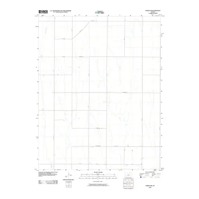
2009 Map of Ensign SW
USGS Topo · Published 2009About this map
Mulberry Creek winds through the northwest corner of this agricultural landscape in Ford County, Kansas. The map depicts a strictly gridded rural environment typical of the High Plains, where the terrain is partitioned by a network of numbered and named section roads. This 2009 survey highlights a transition in local infrastructure, where traditional numerical identifiers like 100 Rd and 105 Rd exist alongside more descriptive thoroughfares such as Warrior Rd, Windy Rd, and Wrangler Rd. The sparse density of structures indicates a focus on large-scale farming and ranching, with the topography defined by the subtle drainage patterns feeding into the creek and across routes like Wilburn Rd and Valley Rd.
Find a feature on this map
18 named features on this map. Tap any name to fly to it.
Don’t see what you’re looking for? This feature index may not catch every label — zoom into the map to look around manually.
Map Details
Editions of this 2009 Ensign SW Map
This is the sole edition of this map. No revisions or reprints were ever made.
Other maps of this area

1892 · Meade
USGS Topo · 1:125,000

1892 · Dodge
USGS Topo · 1:125,000

1955 · Dodge City
USGS Topo · 1:250,000

1958 · Dodge City
USGS Topo · 1:250,000

1959 · Dodge City
USGS Topo · 1:250,000

1967 · Minneola
USGS Topo · 1:24,000

1969 · Meade NE
USGS Topo · 1:24,000
1969 · South Dodge
USGS Topo · 1:24,000
1969 · Fowler
USGS Topo · 1:24,000
1969 · Haggard
USGS Topo · 1:24,000