1967 Map of Minneola
USGS Topo · Published 1968About this map
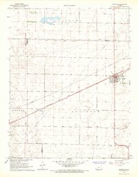
The high plains of southwest Kansas are defined here by a striking intersection of historical and modern infrastructure. The town of Minneola serves as the focal point, situated at the junction of two highways and the Chicago Rock Island and Pacific railroad, which cuts a sharp diagonal across the landscape. The geography is layered with historical markers, most notably the Old Indian Treaty Boundary, which bisects the map horizontally, separating Ford and Clark counties. This line represents a significant legal and territorial legacy in the settlement of the region.
Find a feature on this map
14 named features on this map. Tap any name to fly to it.
Don’t see what you’re looking for? This feature index may not catch every label — zoom into the map to look around manually.
Map Details
Editions of this 1967 Minneola Map
This is the sole edition of this map. No revisions or reprints were ever made.
Other maps of this area

1892 · Meade
USGS Topo · 1:125,000

1892 · Dodge
USGS Topo · 1:125,000

1892 · Spearville
USGS Topo · 1:125,000

1894 · Spearville
USGS Topo · 1:125,000
1896 · Ashland
USGS Topo · 1:125,000

1955 · Pratt
USGS Topo · 1:250,000

1955 · Dodge City
USGS Topo · 1:250,000

1958 · Dodge City
USGS Topo · 1:250,000

1959 · Pratt
USGS Topo · 1:250,000

1959 · Dodge City
USGS Topo · 1:250,000