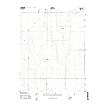
2016 Map of Ensign SW
USGS Topo · Published 2016About this map
Mulberry Creek winds through the northwest corner of this agricultural landscape, marking one of the few natural watercourses in an area defined by a strict section-line road grid. The boundary between Gray and Ford Counties bisects the western portion of the map, following 100th Road and County Road 25. This survey highlights the rural infrastructure of the High Plains, where naming conventions shift from standard alphanumeric designations like A A Road and B B Road to more evocative local identifiers such as Warrior Road, Wildfire Road, and Wrangler Road. The map provides a precise record of land division under the Public Land Survey System, showing the townships of t28s r27w and t29s r26w, which underpin the region's ranching and farming economy.
Find a feature on this map
31 named features on this map. Tap any name to fly to it.
Don’t see what you’re looking for? This feature index may not catch every label — zoom into the map to look around manually.
Map Details
Editions of this 2016 Ensign SW Map
This is the sole edition of this map. No revisions or reprints were ever made.
Other maps of this area
1892 · Meade
USGS Topo · 1:125,000
1892 · Dodge
USGS Topo · 1:125,000

1955 · Dodge City
USGS Topo · 1:250,000

1958 · Dodge City
USGS Topo · 1:250,000

1959 · Dodge City
USGS Topo · 1:250,000
1967 · Minneola
USGS Topo · 1:24,000
1969 · Meade NE
USGS Topo · 1:24,000
1969 · South Dodge
USGS Topo · 1:24,000
1969 · Fowler
USGS Topo · 1:24,000
1969 · Haggard
USGS Topo · 1:24,000