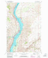
1968 Map of Entiat
USGS Topo · Published 1987About this map
Lake Entiat dominates this Columbia River corridor, marking the landscape where Chelan and Douglas counties meet. The settlement of Entiat is clustered on the western bank, featuring local infrastructure like a Fire Sta, a RR Station along the Burlington Northern line, and Will Risk Memorial Park. Across the water in Douglas County, the community of Orondo serves as a rural hub with the Orondo Sch, Orondo Community Cem, and a Grange Hall situated near the foot of Pine Canyon.
Find a feature on this map
53 named features on this map. Tap any name to fly to it.
Don’t see what you’re looking for? This feature index may not catch every label — zoom into the map to look around manually.
Map Details
Editions of this 1968 Entiat Map
2 editions found
Other maps of this area

1901 · Chelan
USGS Topo · 1:125,000

1957 · Wenatchee
USGS Topo · 1:250,000

1968 · Chelan
USGS Topo · 1:24,000

1968 · Orondo
USGS Topo · 1:24,000

1968 · Waterville
USGS Topo · 1:24,000

1968 · Entiat
USGS Topo · 1:24,000

1968 · Ardenvoir
USGS Topo · 1:24,000

1968 · Baldy Mtn
USGS Topo · 1:24,000
1968 · Douglas
USGS Topo · 1:24,000

1968 · Winesap
USGS Topo · 1:24,000