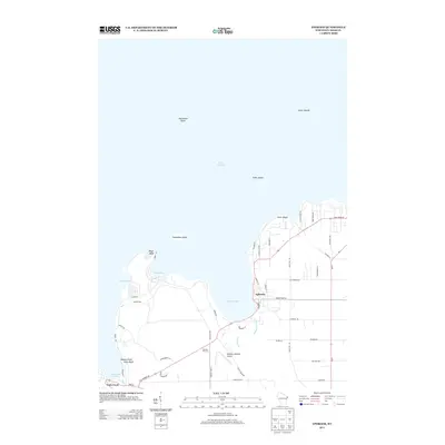
2013 Map of Ephraim
USGS Topo · Published 2013About this map
Ephraim and the surrounding coastline of Green Bay are defined by a deeply indented shoreline of harbors and high bluffs. This coastal landscape includes the sheltered waters of Eagle Harbor and Fish Creek Harbor, which are protected from the open lake by prominent landforms such as Eagle Bluff and Weborg Point Svens Bluff. The interior transition from the village into rural Door County is marked by a network of local thoroughfares including Settlement Rd and German Rd, reflecting the early layout of the peninsula. Local aviation and cultural landmarks are also represented, notably the Ephraim-Gibraltar Airport and the Skyway Drive-In located along the highway corridors. Offshore, the map traces various navigational hazards and landmarks such as Horseshoe Island and the Sister Shoals, providing a detailed look at the maritime geography of the area in 2013.
Find a feature on this map
52 named features on this map. Tap any name to fly to it.
Don’t see what you’re looking for? This feature index may not catch every label — zoom into the map to look around manually.
Map Details
Editions of this 2013 Ephraim Map
This is the sole edition of this map. No revisions or reprints were ever made.
Other maps of this area

1954 · Escanaba
USGS Topo · 1:250,000

1957 · Escanaba
USGS Topo · 1:250,000

1958 · Escanaba
USGS Topo · 1:250,000

1960 · Sister Bay
USGS Topo · 1:62,500

1960 · Ellison Bay
USGS Topo · 1:62,500

1961 · Chambers Island
USGS Topo · 1:62,500

1963 · Cedar River
USGS Topo · 1:62,500

1981 · Marinette
USGS Topo · 1:100,000
1982 · Baileys Harbor West
USGS Topo · 1:24,000
1982 · Ellison Bay
USGS Topo · 1:24,000