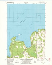
1982 Map of Ephraim
USGS Topo · Published 1983About this map
Peninsula State Park dominates the Door County shoreline in the early 1980s, preserving a large swath of waterfront between Nicolet Bay and the village of Fish Creek. This survey captures the region's character as a established maritime and recreational destination, where the high limestone Sister Bluffs overlook Green Bay and the Sister Islands. The map detail reveals a landscape organized by both tourism and deep-rooted local infrastructure, from the Ephraim-Fish Creek Airport to the numerous historic burial grounds like Blossomburg Cem and Little Sister Cem.
Find a feature on this map
58 named features on this map. Tap any name to fly to it.
Don’t see what you’re looking for? This feature index may not catch every label — zoom into the map to look around manually.
Map Details
Editions of this 1982 Ephraim Map
This is the sole edition of this map. No revisions or reprints were ever made.
Other maps of this area

1954 · Escanaba
USGS Topo · 1:250,000

1957 · Escanaba
USGS Topo · 1:250,000

1958 · Escanaba
USGS Topo · 1:250,000

1960 · Sister Bay
USGS Topo · 1:62,500

1960 · Ellison Bay
USGS Topo · 1:62,500

1961 · Chambers Island
USGS Topo · 1:62,500

1963 · Cedar River
USGS Topo · 1:62,500

1981 · Marinette
USGS Topo · 1:100,000
1982 · Baileys Harbor West
USGS Topo · 1:24,000
1982 · Ellison Bay
USGS Topo · 1:24,000