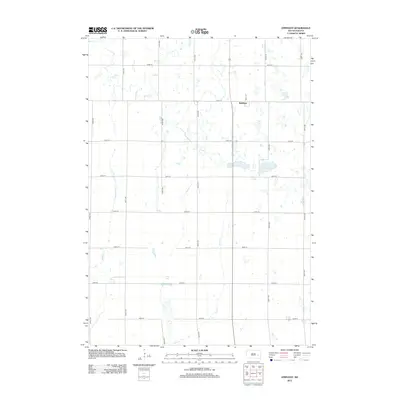
2012 Map of Epiphany
USGS Topo · Published 2012About this map
Epiphany stands as the primary settlement in this section of Hanson County, situated amidst a glacial landscape defined by numerous depressions and wetlands. The map reveals a strictly regulated section-line road grid, where routes like 244th St and Wall St provide access to the rural homesteads scattered throughout the township. Water features dominate the geography, from the larger expanses of Spring Lake and Lutz Lake to the drainage networks of Pierre Cr and Rock Cr. This survey illustrates the persistent agricultural character of southeastern South Dakota in the early 21st century, showing how the land is partitioned into precise geometric plots while accommodating natural features like Long Lake and the winding course of Johnson Cr.
Find a feature on this map
22 named features on this map. Tap any name to fly to it.
Don’t see what you’re looking for? This feature index may not catch every label — zoom into the map to look around manually.
Map Details
Editions of this 2012 Epiphany Map
This is the sole edition of this map. No revisions or reprints were ever made.
Other maps of this area

1899 · Alexandria
USGS Topo · 1:125,000

1955 · Sioux Falls
USGS Topo · 1:250,000

1957 · Alexandria
USGS Topo · 1:24,000

1958 · Sioux Falls
USGS Topo · 1:250,000
1973 · Morris Lake
USGS Topo · 1:24,000

1973 · Ness Chain Lakes
USGS Topo · 1:24,000

1973 · Farmer
USGS Topo · 1:24,000

1973 · Canova SE
USGS Topo · 1:24,000
1973 · Spencer
USGS Topo · 1:24,000
1973 · Bitter Lake
USGS Topo · 1:24,000