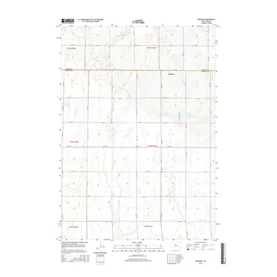
2015 Map of Epiphany
USGS Topo · Published 2015About this map
Epiphany sits at the crossing of the Miner Co Hanson Co line, serving as the primary hub for this agricultural portion of South Dakota. The landscape is defined by its sectional road grid, including 244th St and 427th Ave, which partition the prairie into a network of farms and fields. Water features provide the most distinct natural breaks in the geometric terrain, with Lutz Lake and Spring Lake appearing as prominent basins to the east of the central settlement. The drainage patterns of Rock Cr, Johnson Cr, and Pierre Cr reveal the subtle elevation changes that govern the local hydrology. This 2015 survey details the contemporary state of these townships, from the shores of Long Lake to the scattered section corners of t104n r57w, reflecting the enduring rural character of the region.
Find a feature on this map
29 named features on this map. Tap any name to fly to it.
Don’t see what you’re looking for? This feature index may not catch every label — zoom into the map to look around manually.
Map Details
Editions of this 2015 Epiphany Map
This is the sole edition of this map. No revisions or reprints were ever made.
Other maps of this area

1899 · Alexandria
USGS Topo · 1:125,000

1955 · Sioux Falls
USGS Topo · 1:250,000

1957 · Alexandria
USGS Topo · 1:24,000

1958 · Sioux Falls
USGS Topo · 1:250,000
1973 · Morris Lake
USGS Topo · 1:24,000

1973 · Ness Chain Lakes
USGS Topo · 1:24,000

1973 · Farmer
USGS Topo · 1:24,000

1973 · Canova SE
USGS Topo · 1:24,000
1973 · Spencer
USGS Topo · 1:24,000
1973 · Bitter Lake
USGS Topo · 1:24,000