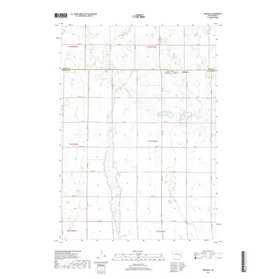
2017 Map of Epiphany
USGS Topo · Published 2017About this map
The unincorporated community of Epiphany sits at the junction of 428th Ave and 244th St, marking a concentrated point of settlement along the border of Miner and Hanson counties. This portion of the Glacial Lake Agassiz region is defined by a complex hydrographic system where Long Lake serves as a central feature, flanked by Lutz Lake and Spring Lake. The land is meticulously subdivided by a grid of section roads like 247th St and 424th Ave, supporting a traditional agrarian economy. Notable for genealogists, the Church of the Epiphany Catholic Cem and Holy Three Kings Cem stand as primary landmarks for the area's social and religious history. Local drainage is managed by small watercourses including Rock Cr, Johnson Cr, and Pierre Cr, which wind through the prairie landscape.
Find a feature on this map
32 named features on this map. Tap any name to fly to it.
Don’t see what you’re looking for? This feature index may not catch every label — zoom into the map to look around manually.
Map Details
Editions of this 2017 Epiphany Map
This is the sole edition of this map. No revisions or reprints were ever made.
Other maps of this area
1899 · Alexandria
USGS Topo · 1:125,000
1955 · Sioux Falls
USGS Topo · 1:250,000
1957 · Alexandria
USGS Topo · 1:24,000
1958 · Sioux Falls
USGS Topo · 1:250,000
1973 · Morris Lake
USGS Topo · 1:24,000
1973 · Ness Chain Lakes
USGS Topo · 1:24,000
1973 · Farmer
USGS Topo · 1:24,000
1973 · Canova SE
USGS Topo · 1:24,000
1973 · Spencer
USGS Topo · 1:24,000
1973 · Bitter Lake
USGS Topo · 1:24,000