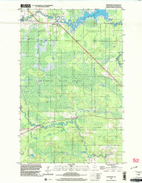
1999 Map of Ericsburg
USGS Topo · Published 2003About this map
Ericsburg sits at the northern edge of this Northwoods landscape, where the meandering Rat Root River winds through the expansive Koochiching State Forest. The geography is defined by a complex network of wetlands and seasonal access routes, notably the numerous Winter Trail markings that crisscross the low-lying terrain. These trails indicate a landscape where travel was historically dictated by the freezing of the ground, a common pattern in the timber and peatlands of northern Minnesota. In the northeast, the river broadens into the wide reaches of Rat Root Lake, while the presence of a Gravel Pit suggests localized extraction for road maintenance in this isolated forest region. The map preserves the 1960s topographic data updated with late-1990s planimetry, capturing the enduring isolation and specific transport patterns of the border country.
Find a feature on this map
7 named features on this map. Tap any name to fly to it.
Don’t see what you’re looking for? This feature index may not catch every label — zoom into the map to look around manually.
Map Details
Editions of this 1999 Ericsburg Map
This is the sole edition of this map. No revisions or reprints were ever made.
Other maps of this area

1919 · International Falls
USGS Topo · 1:62,500

1954 · International Falls
USGS Topo · 1:250,000

1957 · International Falls
USGS Topo · 1:250,000

1958 · International Falls
USGS Topo · 1:250,000

1963 · Ranier
USGS Topo · 1:24,000

1969 · Island View
USGS Topo · 1:24,000

1969 · Ericsburg NW
USGS Topo · 1:24,000

1969 · Ericsburg
USGS Topo · 1:24,000

1969 · Ericsburg SE
USGS Topo · 1:24,000

1969 · Ray
USGS Topo · 1:24,000