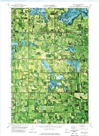
1973 Map of Erie NW
USGS Topo · Published 1976About this map
The Old Indian Treaty Boundary cuts through this rural landscape in Marshall County, marking a historic line across a terrain heavily modified for agriculture. This 1973 orthophotomap shows a complex network of drainage systems, including County Ditch No 20 and County Ditch No 32, which define the rectangular field patterns of the Red River Valley region. Small local landmarks provide anchor points for genealogists, such as Jerusalem Cem and Township Cem located near the small settlement of Espelie.
Find a feature on this map
14 named features on this map. Tap any name to fly to it.
Don’t see what you’re looking for? This feature index may not catch every label — zoom into the map to look around manually.
Map Details
Editions of this 1973 Erie NW Map
This is the sole edition of this map. No revisions or reprints were ever made.
Other maps of this area

1918 · Rollis
USGS Topo · 1:62,500

1919 · Liner
USGS Topo · 1:62,500

1943 · Rollis
USGS Topo · 1:62,500

1954 · Roseau
USGS Topo · 1:250,000

1957 · Roseau
USGS Topo · 1:250,000

1958 · Roseau
USGS Topo · 1:250,000

1962 · Gatzke SE
USGS Topo · 1:24,000

1972 · Erie
USGS Topo · 1:24,000
1972 · Goodridge
USGS Topo · 1:24,000
1972 · Good Lake
USGS Topo · 1:24,000