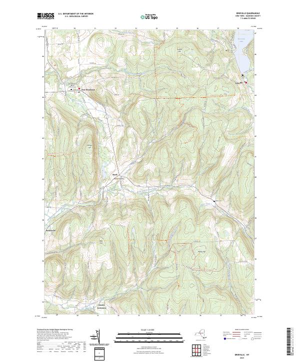
2023 Map of Erieville
USGS Topo · Published 2023About this map
New Woodstock and Erieville serve as the primary hubs in this corner of Madison County, where the high-elevation terrain of the Allegheny Plateau begins to drop into the drainage basins of Central New York. This 2023 survey illustrates a landscape defined by its water sources, from the northern expanse of Tuscarora Lake to the headwaters of the Otselic River and the East Branch Tioughnioga Creek. Historically significant sites like Quaker Settlement and the New Woodstock Baptist Church anchor the local geography, alongside several family-named burial grounds such as the Allard Cem. The intricate network of local roads like Delphi Rd and Co Hwy 52 connects smaller hamlets like Sheds and Puckerville, following the natural contours of prominent rises like Kinney Hill and Muller Hill. Travelers today still utilize the Link Trail (Blue) Trl, which traverses these ridgelines.
Find a feature on this map
75 named features on this map. Tap any name to fly to it.
Don’t see what you’re looking for? This feature index may not catch every label — zoom into the map to look around manually.
Map Details
Editions of this 2023 Erieville Map
This is the sole edition of this map. No revisions or reprints were ever made.
Other maps of this area

1897 · Cazenovia
USGS Topo · 1:62,500

1899 · Cazenovia
USGS Topo · 1:62,500

1902 · Morrisville
USGS Topo · 1:62,500

1903 · Norwich
USGS Topo · 1:62,500

1904 · Pitcher
USGS Topo · 1:62,500

1942 · Oran
USGS Topo · 1:24,000
1943 · Oran
USGS Topo · 1:31,680

1943 · Otselic
USGS Topo · 1:24,000

1943 · De Ruyter
USGS Topo · 1:24,000
1943 · Cazenovia
USGS Topo · 1:24,000