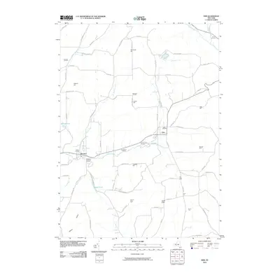
2010 Map of Erin
USGS Topo · Published 2010About this map
Newtown Creek and Baldwin Creek define the drainage of this rural Chemung County landscape, where small hamlets and family-run agricultural operations persist. The village of Breesport serves as a primary local center, while the eponymous Erin sits to the northeast at the junction of several hill roads. Genealogists will find an unusually dense distribution of burial grounds, including the Breesport Old Baptist Cemetery, Scotchtown Cemetery, and the Old Scotchtown Cemetery, indicating the deep roots of early families in this upland region. The terrain is marked by prominent high points such as Red Chalk Hill and Tuthill Ridge, which separate the valley floors from named farmsteads like Twin D Farm. Transport throughout the area is facilitated by a network of named rural routes, including Parrott Rd and Jackson Creek Rd, which track the area's many small streams and hollows.
Find a feature on this map
74 named features on this map. Tap any name to fly to it.
Don’t see what you’re looking for? This feature index may not catch every label — zoom into the map to look around manually.
Map Details
Editions of this 2010 Erin Map
This is the sole edition of this map. No revisions or reprints were ever made.
Other maps of this area

1893 · Ithaca
USGS Topo · 1:62,500

1895 · Ithaca
USGS Topo · 1:62,500

1895 · Elmira
USGS Topo · 1:62,500

1898 · Watkins Glen
USGS Topo · 1:62,500

1901 · Watkins
USGS Topo · 1:62,500

1902 · Waverly
USGS Topo · 1:62,500

1905 · Watkins Glen
USGS Topo · 1:125,000

1950 · Elmira
USGS Topo · 1:250,000

1950 · Alpine
USGS Topo · 1:24,000
1950 · West Danby
USGS Topo · 1:24,000