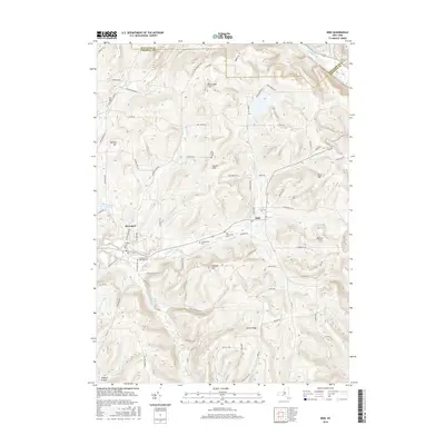
2016 Map of Erin
USGS Topo · Published 2016About this map
Breesport and Erin anchor this Chemung County landscape, where the terrain is defined by a series of prominent ridges and high points. Elevation changes are marked by named summits such as Red Chalk Hill, Mallory Hill, and Laurel Hill, which rise above the valleys of Jackson Creek and Newtown Creek. The area is notably dense with small family and community burial grounds, including the Ennis Cem in the northeast corner near the Schuyler Co Chemung Co line, and the Breesport Old Baptist Cem situated near the village center. This concentration of cemeteries, alongside Van Duzer Cem and Scotchtown Cem, provides significant points of interest for genealogists tracking early settlers in the Southern Tier. The network of rural roads like Walker Hill Rd and Haskins Rd connects these upland settlements to the creek-side communities.
Find a feature on this map
87 named features on this map. Tap any name to fly to it.
Don’t see what you’re looking for? This feature index may not catch every label — zoom into the map to look around manually.
Map Details
Editions of this 2016 Erin Map
This is the sole edition of this map. No revisions or reprints were ever made.
Other maps of this area

1893 · Ithaca
USGS Topo · 1:62,500

1895 · Ithaca
USGS Topo · 1:62,500

1895 · Elmira
USGS Topo · 1:62,500

1898 · Watkins Glen
USGS Topo · 1:62,500

1901 · Watkins
USGS Topo · 1:62,500

1902 · Waverly
USGS Topo · 1:62,500

1905 · Watkins Glen
USGS Topo · 1:125,000

1950 · Elmira
USGS Topo · 1:250,000

1950 · Alpine
USGS Topo · 1:24,000
1950 · West Danby
USGS Topo · 1:24,000