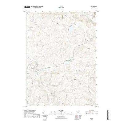
2019 Map of Erin
USGS Topo · Published 2019About this map
Breesport and Erin anchor this Chemung County landscape, where the rural character of New York's Southern Tier remains defined by its deep creek valleys and high ridges. The map reveals a high density of small family and community burial grounds, such as Van Duzer Cem and Hollenbeck Cem, which serve as vital markers for genealogical research in this historically agricultural region. These sites are scattered across the uplands of Red Chalk Hill and Mallory Hill, overlooking the waters of Newtown Creek and Jackson Creek. The drainage patterns of Latta Brook and Baldwin Cr carve through the southern terrain near Tuthill Ridge, illustrating the challenging topography that dictated the winding paths of roads like Breesport Rd and Monkey Run Rd.
Find a feature on this map
92 named features on this map. Tap any name to fly to it.
Don’t see what you’re looking for? This feature index may not catch every label — zoom into the map to look around manually.
Map Details
Editions of this 2019 Erin Map
This is the sole edition of this map. No revisions or reprints were ever made.
Other maps of this area

1893 · Ithaca
USGS Topo · 1:62,500

1895 · Ithaca
USGS Topo · 1:62,500

1895 · Elmira
USGS Topo · 1:62,500

1898 · Watkins Glen
USGS Topo · 1:62,500

1901 · Watkins
USGS Topo · 1:62,500

1902 · Waverly
USGS Topo · 1:62,500

1905 · Watkins Glen
USGS Topo · 1:125,000

1950 · Elmira
USGS Topo · 1:250,000

1950 · Alpine
USGS Topo · 1:24,000
1950 · West Danby
USGS Topo · 1:24,000