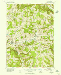
1954 Map of Erin
USGS Topo · Published 1956About this map
Erin and the surrounding Chemung County uplands are defined by a network of steep hills and winding valley roads in the mid-1950s. The Lehigh Valley railroad cuts through the northeastern corner near Park Station, while the southern reaches of the map show the agricultural and rural residential patterns along Newtown Creek and Baldwin Creek. This area is particularly rich for genealogical research, documenting numerous burial grounds such as Old Scotchtown Cem, Hilltop Cem, and the Austin Hill Cem. Local civic life is anchored by landmarks like the County Home and the Jones District Sch near Tuthill Ridge. The landscape is a mosaic of family-named peaks, including Mallory Hill, Laurel Hill, and Langdon Hill, reflecting long-standing land ownership patterns before later modern developments altered the rural character of these valley settlements.
Find a feature on this map
61 named features on this map. Tap any name to fly to it.
Don’t see what you’re looking for? This feature index may not catch every label — zoom into the map to look around manually.
Map Details
Editions of this 1954 Erin Map
This is the sole edition of this map. No revisions or reprints were ever made.
Other maps of this area

1893 · Ithaca
USGS Topo · 1:62,500

1895 · Ithaca
USGS Topo · 1:62,500

1895 · Elmira
USGS Topo · 1:62,500

1898 · Watkins Glen
USGS Topo · 1:62,500

1901 · Watkins
USGS Topo · 1:62,500

1902 · Waverly
USGS Topo · 1:62,500

1905 · Watkins Glen
USGS Topo · 1:125,000

1950 · Elmira
USGS Topo · 1:250,000

1950 · Alpine
USGS Topo · 1:24,000
1950 · West Danby
USGS Topo · 1:24,000