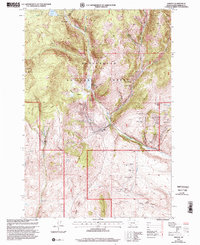
1997 Map of Ermont
USGS Topo · Published 2002About this map
Mining and ranching define this high-altitude landscape within the Beaverhead National Forest as it was documented in the late 1990s. The map reveals an intensive history of extraction, with a dense cluster of claims including the Yellow Band Mine, Argenta Mine, and Carbonate Mine concentrated near the eastern drainages of Clarks Canyon. Further south, the Ermont Mine and its complex of workings like Ermont No 19 Mine dominate the area around Ermont Gulch, where a Mine Dump and various Prospects suggest decades of subsurface activity.
Find a feature on this map
59 named features on this map. Tap any name to fly to it.
Don’t see what you’re looking for? This feature index may not catch every label — zoom into the map to look around manually.
Map Details
Editions of this 1997 Ermont Map
This is the sole edition of this map. No revisions or reprints were ever made.
Other maps of this area

1893 · Dillon
USGS Topo · 1:250,000

1952 · Twin Adams Mountain
USGS Topo · 1:24,000

1952 · Argenta
USGS Topo · 1:24,000

1952 · Bannack
USGS Topo · 1:24,000

1952 · Burns Mountain
USGS Topo · 1:24,000

1952 · Torrey Mountain
USGS Topo · 1:24,000

1952 · Ermont
USGS Topo · 1:24,000

1955 · Dillon
USGS Topo · 1:250,000

1957 · Dillon
USGS Topo · 1:250,000

1958 · Dillon
USGS Topo · 1:250,000