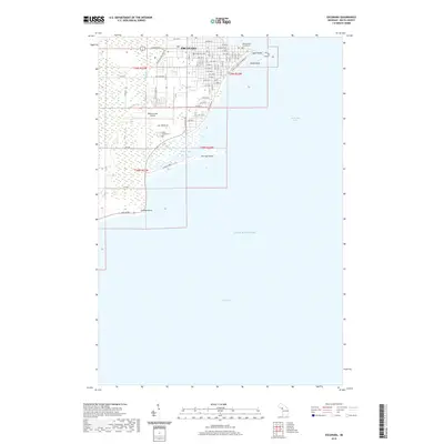
2019 Map of Escanaba
USGS Topo · Published 2019About this map
Escanaba serves as the focal point of this coastal study, situated where the waters of Little Bay de Noc meet the wider reaches of Lake Michigan. The town’s grid is anchored by the Delta County Courthouse and extends toward the waterfront at Sand Point. This 2019 survey captures the developed landscape of the Upper Peninsula, showing the proximity of the Delta County Airport to the marshy lowlands surrounding Portage Bay. Genealogists and local historians can locate established resting places like Lakeview Cem and Holy Cross Cem, while coastal researchers can trace the shoreline south to Portage Point and Fishery Point. The map provides a contemporary record of established routes such as Ludington St and Old State Rd, which connect the urban center to the surrounding wetlands and the winding course of Portage Cr.
Find a feature on this map
28 named features on this map. Tap any name to fly to it.
Don’t see what you’re looking for? This feature index may not catch every label — zoom into the map to look around manually.
Map Details
Editions of this 2019 Escanaba Map
This is the sole edition of this map. No revisions or reprints were ever made.
Other maps of this area

1932 · Gladstone SE
USGS Topo · 1:31,680

1932 · Rapid River SW
USGS Topo · 1:31,680

1932 · Gladstone SW
USGS Topo · 1:31,680

1954 · Escanaba
USGS Topo · 1:250,000

1957 · Escanaba
USGS Topo · 1:250,000

1958 · Escanaba
USGS Topo · 1:250,000

1958 · Gladstone
USGS Topo · 1:62,500

1958 · Escanaba
USGS Topo · 1:62,500

1958 · Peninsula Point
USGS Topo · 1:62,500
1958 · Rapid River
USGS Topo · 1:62,500