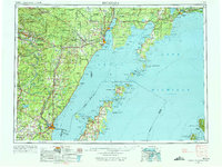
1954 Map of Escanaba
USGS Topo · Published 1975About this map
Little Bay de Noc serves as the industrial and maritime anchor of this mid-century survey, with the port cities of Escanaba and Gladstone positioned as critical rail-to-water transfer points. The landscape is defined by the convergence of major timber and freight lines, including the Chicago and North Western, the Milwaukee Road, and the Soo Line, which weave through the extensive timberlands of the Hiawatha National Forest and Menominee State Forest.
Find a feature on this map
94 named features on this map. Tap any name to fly to it.
Don’t see what you’re looking for? This feature index may not catch every label — zoom into the map to look around manually.
Map Details
Editions of this 1954 Escanaba Map
2 editions found

Other maps of this area

1899 · Sagola
USGS Topo · 1:62,500

1931 · Cooks NE
USGS Topo · 1:31,680

1931 · Steuben SE
USGS Topo · 1:31,680

1931 · Steuben SW
USGS Topo · 1:31,680

1931 · Cooks NW
USGS Topo · 1:31,680

1931 · Seul Choix Point NW
USGS Topo · 1:31,680

1931 · Manistique River SE
USGS Topo · 1:31,680

1931 · Blaney SW
USGS Topo · 1:31,680

1931 · Manistique River SW
USGS Topo · 1:31,680

1932 · Burnt Bluff SW
USGS Topo · 1:31,680