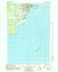
1985 Map of Escanaba
USGS Topo · Published 1985About this map
Escanaba serves as the focal point of this coastal survey, situated on the edge of Little Bay De Noc and the expansive Lake Michigan. The town's layout reflects a dense municipal structure featuring numerous civic and religious institutions, including the William Bonifas Auditorium, St Francis Hospital, and schools like Washington Sch and St Patricks Sch. The shoreline is heavily shaped by maritime and industrial infrastructure, from the Coast Guard Station Radio Mast near Sand Point to the Water Treatment Plant and the recreational waterfront of Ludington Park.
Find a feature on this map
38 named features on this map. Tap any name to fly to it.
Don’t see what you’re looking for? This feature index may not catch every label — zoom into the map to look around manually.
Map Details
Editions of this 1985 Escanaba Map
This is the sole edition of this map. No revisions or reprints were ever made.
Other maps of this area

1932 · Gladstone SE
USGS Topo · 1:31,680

1932 · Rapid River SW
USGS Topo · 1:31,680

1932 · Gladstone SW
USGS Topo · 1:31,680

1954 · Escanaba
USGS Topo · 1:250,000

1957 · Escanaba
USGS Topo · 1:250,000

1958 · Escanaba
USGS Topo · 1:250,000

1958 · Gladstone
USGS Topo · 1:62,500

1958 · Escanaba
USGS Topo · 1:62,500

1958 · Peninsula Point
USGS Topo · 1:62,500
1958 · Rapid River
USGS Topo · 1:62,500