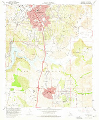
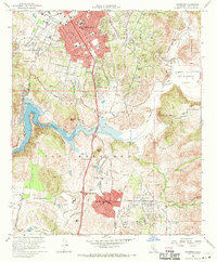
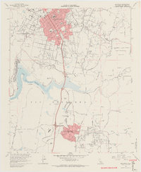
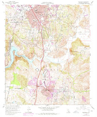
1968 Map of Escondido
USGS Topo · Published 1976About this map
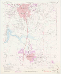
Escondido sits at the heart of this late-1960s landscape, showing a period of significant suburban expansion through the red-tinted development of the city core and the southern reach of Rancho Bernardo. The map reveals a transition from the structured residential grid of the central valley to the rugged hillsides, punctuated by landmarks like City Hall and Station. To the southwest, the waters of Lake Hodges are framed by Bernardo Mtn and Del Dios, while the San Dieguito River and San Pasqual River converge to the east. Local history is recorded in the placement of community institutions such as Felicita Sch, Juniper Sch, and St Marys Sch. The presence of the At & Sf railroad line and numerous quarries and gravel pits indicates the industrial underpinnings of the area, while the Rancho Bernardo Country Club and San Bernardo (Snook) park area highlight the growth of leisure and planned communities during this era.
Find a feature on this map
83 named features on this map. Tap any name to fly to it.
Don’t see what you’re looking for? This feature index may not catch every label — zoom into the map to look around manually.
Map Details
Editions of this 1968 Escondido Map
5 editions found
Other maps of this area

1893 · El Cajon
USGS Topo · 1:62,500

1893 · Escondido
USGS Topo · 1:62,500

1901 · Elcajon
USGS Topo · 1:62,500

1901 · Escondido
USGS Topo · 1:62,500

1901 · San Luis Rey
USGS Topo · 1:125,000

1903 · Cuyamaca
USGS Topo · 1:125,000

1903 · La Jolla
USGS Topo · 1:62,500

1903 · Elcajon
USGS Topo · 1:62,500

1903 · Ramona
USGS Topo · 1:125,000

1904 · Southern California Sheet No. 2
USGS Topo · 1:250,000