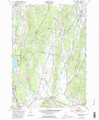
1948 Map of Essex Center
USGS Topo · Published 1987About this map
Browns River and Alder Brook define the rural valley landscapes of Chittenden County during the mid-20th century. The settlement pattern is anchored by Essex Center and the village of Westford, connected by a network of roads that pass through family-named crossroads like Butlers Corners, Pages Corner, and Bowman Corners. Educational and religious foundations of these communities are visible in landmarks such as the Plain Sch, Brookside Sch, and St Anns Cem.
Find a feature on this map
35 named features on this map. Tap any name to fly to it.
Don’t see what you’re looking for? This feature index may not catch every label — zoom into the map to look around manually.
Map Details
Editions of this 1948 Essex Center Map
4 editions found
Other maps of this area

1906 · Burlington
USGS Topo · 1:62,500

1913 · Milton
USGS Topo · 1:48,000

1915 · Milton
USGS Topo · 1:62,500

1919 · Burlington
USGS Topo · 1:62,500

1921 · Richmond
USGS Topo · 1:48,000

1924 · Camels Hump
USGS Topo · 1:62,500

1925 · Mount Mansfield
USGS Topo · 1:48,000

1927 · Mount Mansfield
USGS Topo · 1:62,500

1944 · Milton
USGS Topo · 1:62,500

1944 · Mount Mansfield
USGS Topo · 1:62,500