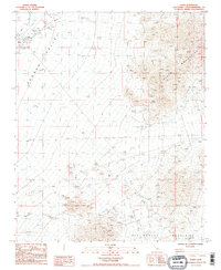
1985 Map of Essex
USGS Topo · Published 1985About this map
The settlement of Essex serves as the focal point for this desert survey, positioned along the At&SF railroad where a complex system of levees protects the infrastructure from the seasonal runoff of a nearby wash. The landscape is dominated by the broad Fenner Valley, which transitions into the higher elevations of the Piute Mountains and the Old Woman Mountains.
Find a feature on this map
21 named features on this map. Tap any name to fly to it.
Don’t see what you’re looking for? This feature index may not catch every label — zoom into the map to look around manually.
Map Details
Editions of this 1985 Essex Map
2 editions found
Other maps of this area

1942 · Amboy
USGS Topo · 1:250,000

1943 · Amboy
USGS Topo · 1:250,000

1943 · Essex
USGS Topo · 1:62,500

1943 · Danby
USGS Topo · 1:62,500

1943 · Fenner
USGS Topo · 1:62,500

1954 · Needles
USGS Topo · 1:250,000

1956 · Needles
USGS Topo · 1:250,000

1956 · Fenner
USGS Topo · 1:62,500

1956 · Essex
USGS Topo · 1:62,500

1956 · Colton Well
USGS Topo · 1:62,500