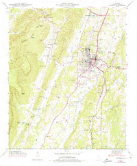
1946 Map of Estelle
USGS Topo · Published 1975About this map
La Fayette serves as the central hub of this Walker County landscape, showing its transition from a rail-dependent center to an area increasingly defined by automotive and industrial infrastructure. The city is bisected by the Central of Georgia railroad, while the Southern line traces the floor of Burnt Mill Valley to the west. This valley is hemmed in by the massive uplift of Pigeon Mountain, which features distinctive landforms like Atwood Point and McWhorter Gulf.
Find a feature on this map
92 named features on this map. Tap any name to fly to it.
Don’t see what you’re looking for? This feature index may not catch every label — zoom into the map to look around manually.
Map Details
Editions of this 1946 Estelle Map
3 editions found
Other maps of this area

1886 · Ringgold
USGS Topo · 1:125,000

1892 · Ringgold
USGS Topo · 1:125,000

1935 · Catlett
USGS Topo · 1:24,000

1935 · Durham
USGS Topo · 1:24,000

1935 · Nickajack Gap
USGS Topo · 1:24,000

1936 · Kensington
USGS Topo · 1:24,000

1936 · Estelle
USGS Topo · 1:24,000

1936 · Dougherty Gap
USGS Topo · 1:24,000
1936 · Cedar Grove
USGS Topo · 1:24,000

1946 · Kensington
USGS Topo · 1:24,000