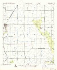
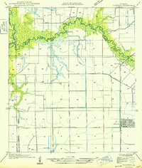
1949 Map of Estherwood
USGS Topo · Published 1949About this map
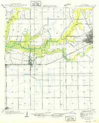
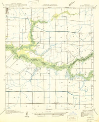
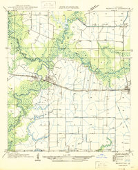
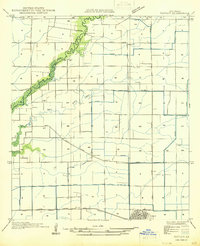
The low-lying rice prairie of Acadia Parish is defined here by an intricate web of irrigation and transportation, where Bayou Plaquemine Brule meanders through the landscape. The growth of Crowley and the surrounding agricultural settlements of Estherwood and Midland was tied directly to the Southern Pacific and Missouri Pacific railroads. This 1949 compilation, based on earlier field examinations and aerial photography, reveals a sophisticated water management system necessary for local agriculture, including the Estherwood Canal and Roller Canal. Industrial markers such as a Pumping Plant and the Ferry crossing on the bayou indicate the infrastructure used to move both water and people across the parish before more modern crossings were established. The grid-like survey lines of the Louisiana Meridian provide the framework for the varied land grants and township sections that shaped the region's development.
Find a feature on this map
17 named features on this map. Tap any name to fly to it.
Don’t see what you’re looking for? This feature index may not catch every label — zoom into the map to look around manually.
Map Details
Editions of this 1949 Estherwood Map
This is the sole edition of this map. No revisions or reprints were ever made.
Other maps of this area

1935 · Branch
USGS Topo · 1:31,680
1946 · Morse
USGS Topo · 1:31,680
1946 · Mermentau
USGS Topo · 1:31,680
1946 · Kaplan
USGS Topo · 1:31,680

1946 · Rayne
USGS Topo · 1:31,680

1947 · Evangeline
USGS Topo · 1:31,680

1947 · Branch
USGS Topo · 1:31,680
1947 · Iota
USGS Topo · 1:31,680
1949 · Gueydan
USGS Topo · 1:31,680

1952 · Lake Charles
USGS Topo · 1:250,000