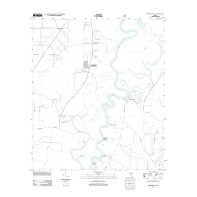
2012 Map of Estiffanulga
USGS Topo · Published 2012About this map
The Apalachicola River defines the landscape of this Florida panhandle quadrangle, winding through a complex network of sloughs and landings in 2012. The river’s serpentine path is flanked by features such as Ammonia River Sand Slough and Raccoon Slough, illustrating the dynamic nature of this wetland environment. Small settlements like Sharpstown and New Hope sit inland from the eastern banks, connected by rural routes such as Co Hwy 333 and Ray Kever Rd. For those tracing local heritage, the presence of the Woods Cem and landmarks like Ammonia Camp provide specific points of interest. The river itself serves as a hub of activity, noted by numerous historical access points including Muscogee Landing, Mosquito Landing, and Gunn Landing. Terrain variations are subtle, with Long Ridge standing out near the water’s edge.
Find a feature on this map
57 named features on this map. Tap any name to fly to it.
Don’t see what you’re looking for? This feature index may not catch every label — zoom into the map to look around manually.
Map Details
Editions of this 2012 Estiffanulga Map
This is the sole edition of this map. No revisions or reprints were ever made.
Other maps of this area

1944 · Clarksville
USGS Topo · 1:31,680

1945 · Dead Lake
USGS Topo · 1:31,680

1945 · Blountstown
USGS Topo · 1:31,680

1945 · Clarksville
USGS Topo · 1:31,680

1945 · Estiffanulga
USGS Topo · 1:31,680

1945 · Orange
USGS Topo · 1:31,680

1945 · Bristol
USGS Topo · 1:31,680

1945 · Frink
USGS Topo · 1:31,680

1945 · Woods
USGS Topo · 1:31,680
1946 · Wilma
USGS Topo · 1:31,680