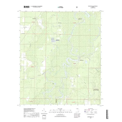
2018 Map of Estiffanulga
USGS Topo · Published 2018About this map
The Apalachicola River winds through a dense network of sloughs, lakes, and wetlands at the border of Liberty and Calhoun Counties. This riverine landscape is defined by its shifting waterways, including the Iamonia River and notable bodies of water like Muscogee Lake and McDougal Lake. Along the eastern bank, the settlement of Estiffanulga sits near the river's edge, while the western side features the communities of Sharpstown and New Hope. The southern portion of the map is dominated by the Apalachicola National Forest, which contains the Florida National Scenic Trail and local landmarks like Iamonia Ridge. Cultural markers like the Woods Cem and Marysville School Rd provide evidence of rural settlement patterns amidst the complex hydrology of the Florida panhandle's river bottoms.
Find a feature on this map
63 named features on this map. Tap any name to fly to it.
Don’t see what you’re looking for? This feature index may not catch every label — zoom into the map to look around manually.
Map Details
Editions of this 2018 Estiffanulga Map
This is the sole edition of this map. No revisions or reprints were ever made.
Other maps of this area

1944 · Clarksville
USGS Topo · 1:31,680

1945 · Dead Lake
USGS Topo · 1:31,680

1945 · Blountstown
USGS Topo · 1:31,680

1945 · Clarksville
USGS Topo · 1:31,680

1945 · Estiffanulga
USGS Topo · 1:31,680

1945 · Orange
USGS Topo · 1:31,680

1945 · Bristol
USGS Topo · 1:31,680

1945 · Frink
USGS Topo · 1:31,680

1945 · Woods
USGS Topo · 1:31,680
1946 · Wilma
USGS Topo · 1:31,680