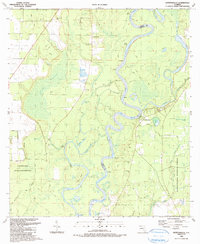
1990 Map of Estiffanulga
USGS Topo · Published 1990About this map
The Apalachicola River winds through a dense network of oxbow lakes, sloughs, and wetlands at the border of Liberty and Calhoun Counties in the late 20th century. This riverine landscape is defined by its complex hydrology, featuring numerous named water bodies like Outside Lake, Joe Davis Lake, and McDougal Lake that flank the main channel's Bee Tree Reach. The map records the historical Forbes Purchase Boundary, a remnant of early 19th-century land grants that still influenced surveying at the time of this 1990 revision.
Find a feature on this map
57 named features on this map. Tap any name to fly to it.
Don’t see what you’re looking for? This feature index may not catch every label — zoom into the map to look around manually.
Map Details
Editions of this 1990 Estiffanulga Map
This is the sole edition of this map. No revisions or reprints were ever made.
Other maps of this area

1944 · Clarksville
USGS Topo · 1:31,680

1945 · Dead Lake
USGS Topo · 1:31,680

1945 · Blountstown
USGS Topo · 1:31,680

1945 · Clarksville
USGS Topo · 1:31,680

1945 · Estiffanulga
USGS Topo · 1:31,680

1945 · Orange
USGS Topo · 1:31,680

1945 · Bristol
USGS Topo · 1:31,680

1945 · Frink
USGS Topo · 1:31,680

1945 · Woods
USGS Topo · 1:31,680
1946 · Wilma
USGS Topo · 1:31,680