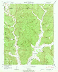
1948 Map of Estill Fork
USGS Topo · Published 1973About this map
The Larkin Fork and Estill Fork rivers carve deep, narrow valleys through this dissected plateau on the Alabama-Tennessee border during the late 1940s. The landscape is defined by its isolation, where small communities like Francisco and Estillfork grew around creek-side bottomlands. The map reveals a high density of family-named landmarks and local institutions, including the Beech Grove School, Grays Chapel, and the Freedom Sch. These settlements are interconnected by primitive roads that follow the contour of the gaps, such as Walnut Gap and Low Gap.
Find a feature on this map
115 named features on this map. Tap any name to fly to it.
Don’t see what you’re looking for? This feature index may not catch every label — zoom into the map to look around manually.
Map Details
Editions of this 1948 Estill Fork Map
3 editions found
Other maps of this area

1888 · Scottsboro
USGS Topo · 1:125,000

1892 · Scottsboro
USGS Topo · 1:125,000

1928 · Decherd
USGS Topo · 1:62,500

1936 · King Cove
USGS Topo · 1:24,000

1936 · Hollytree
USGS Topo · 1:24,000

1936 · Beans Creek
USGS Topo · 1:24,000

1936 · Mud Creek
USGS Topo · 1:24,000

1936 · Hytop
USGS Topo · 1:24,000

1936 · Princeton
USGS Topo · 1:24,000

1936 · Huntland
USGS Topo · 1:24,000