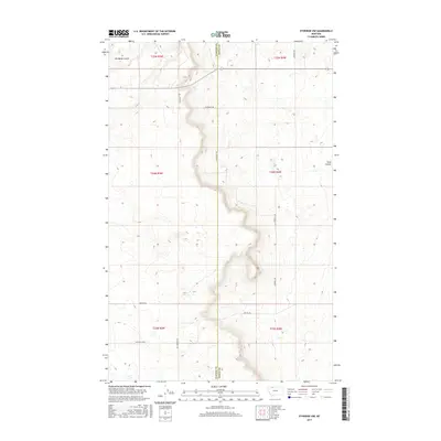
2017 Map of Ethridge NW
USGS Topo · Published 2017About this map
The Glacier and Toole County line bisects this high-plains landscape, where the geography is defined by deep, winding drainages and a sparse network of agricultural roads. Two prominent terrain features, Old Maids Coulee in the northwest and Sand Coulee to the east, demonstrate the characteristic erosion patterns of this region. The map reveals a history of land ownership and local family legacy through its named thoroughfares, including Dahlquist Rd, Hartwell Rd, and Mrs Luedtke Rd. These routes connect isolated farmsteads and sections, while the Old Kevin Hwy cuts across the southwestern corner, reflecting older transportation corridors that preceded modern state infrastructure. This document provides a clear view of the rural township and range system during the early twenty-first century, documenting the enduring homestead-era boundaries of T34N and T35N.
Find a feature on this map
19 named features on this map. Tap any name to fly to it.
Don’t see what you’re looking for? This feature index may not catch every label — zoom into the map to look around manually.
Map Details
Editions of this 2017 Ethridge NW Map
This is the sole edition of this map. No revisions or reprints were ever made.
Other maps of this area

1907 · Blackfoot Res.
USGS Topo · 1:48,000

1909 · Cut Bank
USGS Topo · 1:125,000

1912 · Cut Bank
USGS Topo · 1:125,000

1960 · Cut Bank
USGS Topo · 1:250,000

1963 · Cut Bank
USGS Topo · 1:250,000

1964 · Cut Bank
USGS Topo · 1:250,000
1966 · Ethridge
USGS Topo · 1:24,000

1966 · Ethridge NW
USGS Topo · 1:24,000
1966 · Aloe
USGS Topo · 1:24,000
1966 · Boru Spring
USGS Topo · 1:24,000