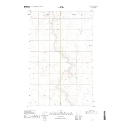
2020 Map of Ethridge NW
USGS Topo · Published 2020About this map
The Glacier Co Toole Co boundary line bisects this portion of the northern Montana plains, revealing a landscape defined by expansive drainage patterns and a sparsely populated section-line road network. The most prominent terrain feature is Sand Coulee, which winds through the eastern quadrants. This 2020 survey illustrates the modern rural infrastructure of the region, where family names are preserved through the naming of local routes such as Dahlquist Rd, Hartwell Rd, Luedtke Rd, and Mrs Luedtke Rd. The Old Kevin Hwy cuts across the southern reach, anchoring the transportation grid of these high plains. The map provides a precise look at the township and range divisions, specifically covering portions of T33N through T35N, where the drainage systems and coulees dictate the placement of local thoroughfares like Potter Rd and Nepstad Rd.
Find a feature on this map
15 named features on this map. Tap any name to fly to it.
Don’t see what you’re looking for? This feature index may not catch every label — zoom into the map to look around manually.
Map Details
Editions of this 2020 Ethridge NW Map
This is the sole edition of this map. No revisions or reprints were ever made.
Other maps of this area

1907 · Blackfoot Res.
USGS Topo · 1:48,000

1909 · Cut Bank
USGS Topo · 1:125,000

1912 · Cut Bank
USGS Topo · 1:125,000

1960 · Cut Bank
USGS Topo · 1:250,000

1963 · Cut Bank
USGS Topo · 1:250,000

1964 · Cut Bank
USGS Topo · 1:250,000
1966 · Ethridge
USGS Topo · 1:24,000

1966 · Ethridge NW
USGS Topo · 1:24,000
1966 · Aloe
USGS Topo · 1:24,000
1966 · Boru Spring
USGS Topo · 1:24,000