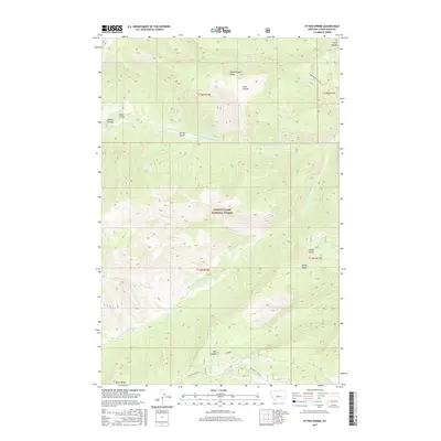
2017 Map of Ettien Spring
USGS Topo · Published 2017About this map
Lewis & Clark National Forest encompasses the high-elevation landscape of this 2017 survey, where a complex network of ridges and watercourses defines the geography. The terrain is anchored by massive features such as Woodchopper Ridge and Ettien Ridge, with the latter giving way to the namesake Ettien Spring and the steep Ettien Gulch. This area serves as a significant drainage basin, where the Middle Fork Judith River and Lost Fork Judith River carve through the mountain front.
Find a feature on this map
24 named features on this map. Tap any name to fly to it.
Don’t see what you’re looking for? This feature index may not catch every label — zoom into the map to look around manually.
Map Details
Editions of this 2017 Ettien Spring Map
This is the sole edition of this map. No revisions or reprints were ever made.
Other maps of this area

1886 · Little Belt Mts.
USGS Topo · 1:250,000

1894 · Little Belt Mts.
USGS Topo · 1:250,000

1897 · Little Belt Mts.
USGS Topo · 1:250,000

1898 · Little Belt Mts.
USGS Topo · 1:250,000

1902 · Little Belt Mts.
USGS Topo · 1:250,000

1948 · White Sulphur Springs
USGS Topo · 1:250,000

1958 · White Sulphur Springs
USGS Topo · 1:250,000

1961 · White Sulphur Springs
USGS Topo · 1:250,000
1961 · Yogo Peak
USGS Topo · 1:24,000
1961 · Sand Point
USGS Topo · 1:24,000