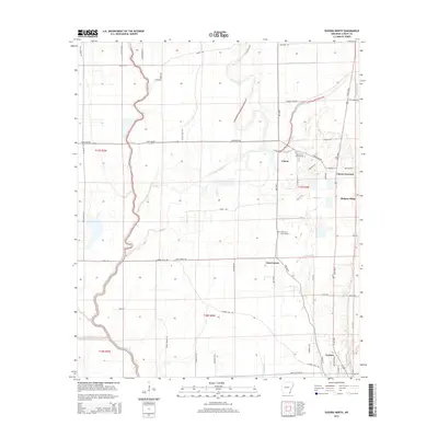
2014 Map of Eudora North
USGS Topo · Published 2014About this map
The Boeuf River and Bayou Macon define the low-lying agricultural landscape of Chicot County in the early 21st century. This region is characterized by its intricate drainage network, featuring several named waterways like Caney Bayou, Big Bayou, and Hill Bayou, alongside engineering works such as Canal Number 4. The settlement pattern centers around the northern edge of Eudora and smaller communities like Gum Corner, Chicot, and Hickory Ridge. The map provides specific locations for genealogical research, including Holly Grove Cem Number 1 and Holly Grove Cem Number 2. The road system is extensive, including family-named routes such as Carlton Rd, Mazzanti Rd, and Lonnie Knight Rd, which trace the section lines and levees of the Arkansas Delta.
Find a feature on this map
53 named features on this map. Tap any name to fly to it.
Don’t see what you’re looking for? This feature index may not catch every label — zoom into the map to look around manually.
Map Details
Editions of this 2014 Eudora North Map
This is the sole edition of this map. No revisions or reprints were ever made.
Other maps of this area

1936 · Eudora
USGS Topo · 1:62,500

1936 · Lake Village
USGS Topo · 1:62,500

1939 · Readland
USGS Topo · 1:62,500

1939 · Refuge
USGS Topo · 1:62,500

1953 · Greenwood
USGS Topo · 1:250,000

1955 · Lake Village
USGS Topo · 1:62,500

1956 · Greenwood
USGS Topo · 1:250,000

1957 · Eudora
USGS Topo · 1:62,500
1970 · Readland
USGS Topo · 1:24,000
1970 · Red Leaf
USGS Topo · 1:24,000