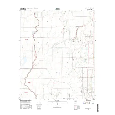
2017 Map of Eudora North
USGS Topo · Published 2017About this map
Eudora and the smaller settlement of Chicot anchor this delta landscape in southeastern Arkansas, where the terrain is defined by a dense network of slow-moving waterways and drainage improvements. The Boeuf River winds prominently along the western boundary, while Bayou Macon and Caney Bayou cut through the central and southern reaches. For genealogists, the map identifies Holly Grove Cem Number 1 and Holly Grove Cem Number 2, providing specific locations for family research near the Chicot community. The influence of local families on the landscape is evident in the many named roads, such as H G Black Rd, Brooks Parker Rd, and Nunnelee Rd. In the northeast corner near Shelton, the intricate curves of Hill Bayou contrast with the engineered straight lines of Canal Number 1, illustrating the region's long history of managing water for agriculture.
Find a feature on this map
52 named features on this map. Tap any name to fly to it.
Don’t see what you’re looking for? This feature index may not catch every label — zoom into the map to look around manually.
Map Details
Editions of this 2017 Eudora North Map
This is the sole edition of this map. No revisions or reprints were ever made.
Other maps of this area

1936 · Eudora
USGS Topo · 1:62,500

1936 · Lake Village
USGS Topo · 1:62,500

1939 · Readland
USGS Topo · 1:62,500

1939 · Refuge
USGS Topo · 1:62,500

1953 · Greenwood
USGS Topo · 1:250,000

1955 · Lake Village
USGS Topo · 1:62,500

1956 · Greenwood
USGS Topo · 1:250,000

1957 · Eudora
USGS Topo · 1:62,500
1970 · Readland
USGS Topo · 1:24,000
1970 · Red Leaf
USGS Topo · 1:24,000