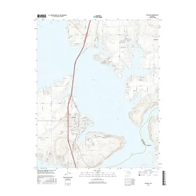
2016 Map of Eufaula
USGS Topo · Published 2016About this map
Eufaula Lake dominates this McIntosh County landscape, its winding shoreline and intricate inlets defining the modern character of the region. This 2016 survey shows the prominent presence of the lake as it surrounds the town of Eufaula, with numerous residential developments such as those found near Terra Lakes Lake and the settlement of Texanna. For local historians and genealogists, the map is particularly valuable for its documentation of several area burial grounds, including Fishertown Cem, Greenwood Cem, and Evergreen Cem. The map also captures the crossing of the Pittsburg Co McIntosh Co line near Longtown, alongside minor waterways like Baptizing Cr and Carr Cr. The dense network of local roads, such as Bridgeport Rd and Texanna Rd, reveals the growth of lakeside communities and the infrastructure supporting this established Oklahoma recreation and residential hub.
Find a feature on this map
114 named features on this map. Tap any name to fly to it.
Don’t see what you’re looking for? This feature index may not catch every label — zoom into the map to look around manually.
Map Details
Editions of this 2016 Eufaula Map
This is the sole edition of this map. No revisions or reprints were ever made.
Other maps of this area

1900 · Sansbois
USGS Topo · 1:125,000

1900 · Canadian
USGS Topo · 1:125,000

1909 · Sans Bois
USGS Topo · 1:125,000

1911 · Sansbois
USGS Topo · 1:125,000

1946 · Fort Smith
USGS Topo · 1:250,000

1962 · Pierce
USGS Topo · 1:24,000

1963 · Warner NW
USGS Topo · 1:24,000

1963 · Stidham
USGS Topo · 1:24,000

1963 · Eufaula
USGS Topo · 1:24,000

1963 · Checotah
USGS Topo · 1:24,000