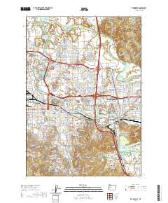
2020 Map of Eugene East
USGS Topo · Published 2020About this map
The confluence of the McKenzie River and the Willamette River shapes this landscape of the southern Willamette Valley, where the neighboring cities of Eugene and Springfield meet. The map documents a complex urban and natural interface, with the University of Oregon and Northwest Christian University campuses anchoring the central district. Significant local history is preserved in sites like the Eugene Pioneer Cemetery and the Lane County Courthouse, while physical geography is defined by prominent rises such as Skinner Butte and Gillespie Butte.
Find a feature on this map
95 named features on this map. Tap any name to fly to it.
Don’t see what you’re looking for? This feature index may not catch every label — zoom into the map to look around manually.
Map Details
Editions of this 2020 Eugene East Map
This is the sole edition of this map. No revisions or reprints were ever made.
Other maps of this area

1910 · Eugene
USGS Topo · 1:62,500

1921 · Cottage Grove
USGS Topo · 1:62,500

1935 · Lowell
USGS Topo · 1:96,000

1940 · Eugene
USGS Topo · 1:62,500

1942 · Lowell
USGS Topo · 1:125,000

1946 · Eugene
USGS Topo · 1:62,500

1949 · Eugene
USGS Topo · 1:62,500

1950 · Marcola
USGS Topo · 1:62,500

1952 · Marcola
USGS Topo · 1:62,500

1953 · Salem
USGS Topo · 1:250,000