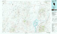
1985 Map of Eugene Mts
USGS Topo · Published 1985About this map
The Nevada-Massachusetts Tungsten Mine stands as a central industrial landmark in this mid-1980s look at the Humboldt and Pershing County borderlands. The landscape is defined by the extraction of minerals and the essential movement of goods across the Black Rock Desert, with the Southern Pacific and Union Pacific railroads providing the primary lifelines through the arid terrain. Small rail-side settlements like Sulphur, Jungo, and Mill City represent the sparse human footprint in an area dominated by prominent peaks such as Majuba Mtn and the Rosebud Mountains. Water management is critical in this high-desert environment, evidenced by the Upper Pitt-Taylor Reservoir and Lower Pitt-Taylor Reservoir along the Humboldt River. For researchers and historians, this map documents the late-century configuration of numerous mining operations, including the Golden Eagle Mine and Standard Mine, alongside a complex network of springs and washes like Rabbithole Creek.
Find a feature on this map
115 named features on this map. Tap any name to fly to it.
Don’t see what you’re looking for? This feature index may not catch every label — zoom into the map to look around manually.
Map Details
Editions of this 1985 Eugene Mts Map
2 editions found
Other maps of this area

1882 · Paradise
USGS Topo · 1:250,000

1886 · Disaster
USGS Topo · 1:250,000

1886 · Granite Range
USGS Topo · 1:250,000

1889 · Long Valley
USGS Topo · 1:250,000

1893 · Paradise
USGS Topo · 1:250,000

1893 · Disaster
USGS Topo · 1:250,000

1894 · Granite Range
USGS Topo · 1:250,000

1931 · Lovelock
USGS Topo · 1:250,000

1932 · Sonoma Range
USGS Topo · 1:250,000

1935 · Lovelock
USGS Topo · 1:250,000