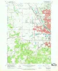
1967 Map of Eugene West
USGS Topo · Published 1969About this map
The western expansion of Eugene is captured during a period of significant suburban development and industrial infrastructure growth. The landscape is defined by the corridors of the Southern Pacific and the Oregon Electric Line, which navigate between the rising elevations of Oak Hill and Murray Hill. This 1960s survey documents a transitional era where agricultural lands were increasingly occupied by residential tracts and civic institutions, notably the dense concentration of schools such as Willamette High Sch and North Eugene High Sch. To the north, the Mahlon Sweet Airport serves as a major regional hub, while the presence of the Balboa Park Drag Strip and the Eugene Speedway reflects the era's local recreation culture. Religious and memorial sites, including the Carmel of Maria Regina Monastery and several cemeteries, provide stable landmarks amidst the shifting corporate boundaries of Santa Clara and Danebo.
Find a feature on this map
72 named features on this map. Tap any name to fly to it.
Don’t see what you’re looking for? This feature index may not catch every label — zoom into the map to look around manually.
Map Details
Editions of this 1967 Eugene West Map
3 editions found
Other maps of this area

1909 · Elmira
USGS Topo · 1:62,500

1910 · Eugene
USGS Topo · 1:62,500

1921 · Cottage Grove
USGS Topo · 1:62,500

1922 · Elmira
USGS Topo · 1:62,500

1940 · Eugene
USGS Topo · 1:62,500

1942 · Elmira
USGS Topo · 1:62,500

1942 · Crow
USGS Topo · 1:62,500

1945 · Crow
USGS Topo · 1:62,500

1946 · Eugene
USGS Topo · 1:62,500

1949 · Eugene
USGS Topo · 1:62,500