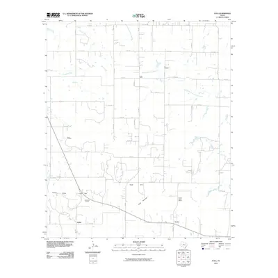
2010 Map of Eula
USGS Topo · Published 2010About this map
The Callahan Divide defines the southern reach of this landscape, where the terrain drops into Eagle Cove near the prominent rise of Eagle Mountain. This 2010 survey of Callahan County captures the rural character of Central Texas, centered on the unincorporated community of Eula and the smaller settlements of Dudley and Denton. The drainage network is clearly defined by the North Prong Pecan Bayou and Spring Creek, which navigate a grid of county roads that have replaced the wagon tracks of earlier eras.
Find a feature on this map
47 named features on this map. Tap any name to fly to it.
Don’t see what you’re looking for? This feature index may not catch every label — zoom into the map to look around manually.
Map Details
Editions of this 2010 Eula Map
This is the sole edition of this map. No revisions or reprints were ever made.
Other maps of this area

1890 · Abilene
USGS Topo · 1:125,000

1892 · Abilene
USGS Topo · 1:125,000

1931 · Baird
USGS Topo · 1:125,000

1932 · Baird
USGS Topo · 1:125,000

1954 · Abilene
USGS Topo · 1:250,000

1957 · Kirby Lake
USGS Topo · 1:62,500

1957 · Abilene East
USGS Topo · 1:24,000

1958 · Abilene
USGS Topo · 1:250,000
1966 · Baird
USGS Topo · 1:24,000
1966 · Cub Hollow
USGS Topo · 1:24,000