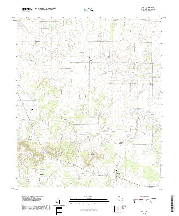
2022 Map of Eula
USGS Topo · Published 2022About this map
Eula serves as a central hub in this section of Callahan County, situated at the intersection of Farm to Market roads and local county routes. The landscape is defined by the headwaters of the N Prong Pecan Bayou and Spring Cr, which carve through the undulating terrain of the Rolling Plains. To the south, the topography becomes more pronounced at Eagle Mtn and the prominent Lytle Gap, a natural pass used for local transit near the settlement of Dudley. Genealogists will find a high density of small burial grounds scattered across the quadrangle, including the Seaton Cem to the west and the Kendrick Cem near Denton. The arrangement of these cemeteries and rural communities like Eagle Cove illustrates a long-standing pattern of dispersed agricultural settlement and family landholdings maintained into the twenty-first century.
Find a feature on this map
67 named features on this map. Tap any name to fly to it.
Don’t see what you’re looking for? This feature index may not catch every label — zoom into the map to look around manually.
Map Details
Editions of this 2022 Eula Map
This is the sole edition of this map. No revisions or reprints were ever made.
Other maps of this area

1890 · Abilene
USGS Topo · 1:125,000

1892 · Abilene
USGS Topo · 1:125,000

1931 · Baird
USGS Topo · 1:125,000

1932 · Baird
USGS Topo · 1:125,000

1954 · Abilene
USGS Topo · 1:250,000

1957 · Kirby Lake
USGS Topo · 1:62,500

1957 · Abilene East
USGS Topo · 1:24,000

1958 · Abilene
USGS Topo · 1:250,000
1966 · Baird
USGS Topo · 1:24,000
1966 · Cub Hollow
USGS Topo · 1:24,000