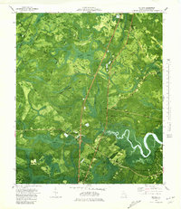
1980 Map of Eulonia
USGS Topo · Published 1980About this map
The winding Sapelo River defines the coastal character of McIntosh County, where tidal inlets and dense bottomlands dominate the terrain. This 1980 orthophotomap, derived from 1974 aerial photography and earlier planetable surveys, highlights the intricate drainage systems of Mortar Swamp, Oscar Swamp, and Buck Swamp. The local economy and settlement patterns are clearly visible, from the historic Seaboard Coast Line Railroad corridor passing through Brickston and Warsaw to the coastal communities of Bellville Point and Fairhope. Genealogists and local historians will find significant value in the distribution of community landmarks, including Second Credit Hill Ch, Shorter Chapel, and the Mc Intosh Cem. The map also documents industrial and infrastructure footprints like the Quarry and a Sewage Disposal Pond near Eulonia.
Find a feature on this map
51 named features on this map. Tap any name to fly to it.
Don’t see what you’re looking for? This feature index may not catch every label — zoom into the map to look around manually.
Map Details
Editions of this 1980 Eulonia Map
This is the sole edition of this map. No revisions or reprints were ever made.
Other maps of this area

1918 · Everett City
USGS Topo · 1:62,500

1920 · Sapelo River
USGS Topo · 1:62,500

1920 · Everett City
USGS Topo · 1:62,500

1921 · Darien
USGS Topo · 1:62,500

1943 · Ludowici
USGS Topo · 1:62,500

1943 · Sapelo River
USGS Topo · 1:62,500

1944 · Everett City
USGS Topo · 1:62,500

1945 · Sapelo River
USGS Topo · 1:62,500

1946 · Brunswick
USGS Topo · 1:250,000

1948 · Brunswick
USGS Topo · 1:250,000