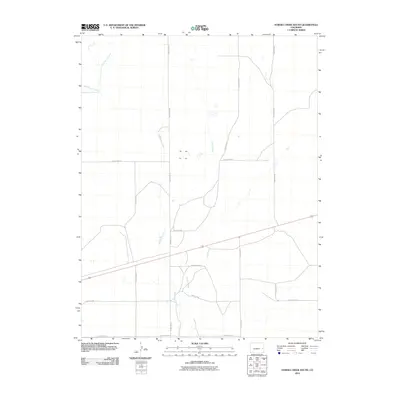
2010 Map of Eureka Creek South
USGS Topo · Published 2010About this map
Eureka Creek winds through the expansive High Plains of eastern Colorado in this 2010 topographic record of Cheyenne County. The landscape is defined by its wide drainage patterns and a highly organized grid of rural infrastructure, reflecting a region deeply tied to agricultural land management. The intersection of intermittent watercourses like Big Spring Creek and Little Spring Creek with the local road system highlights the essential relationship between the natural hydrology of the plains and the human imprint of section-line travel. Long, straight thoroughfares such as County Road R and County Road M segment the terrain into the large parcels characteristic of this part of the state, where the few named geographic features often center on these critical, seasonal water sources.
Find a feature on this map
13 named features on this map. Tap any name to fly to it.
Don’t see what you’re looking for? This feature index may not catch every label — zoom into the map to look around manually.
Map Details
Editions of this 2010 Eureka Creek South Map
This is the sole edition of this map. No revisions or reprints were ever made.
Other maps of this area

1891 · Kit Carson
USGS Topo · 1:125,000

1893 · Kit Carson
USGS Topo · 1:125,000

1954 · Lamar
USGS Topo · 1:250,000

1958 · Lamar
USGS Topo · 1:250,000

1981 · Cheyenne Wells
USGS Topo · 1:100,000
1982 · Kit Carson
USGS Topo · 1:24,000

1982 · Kit Carson 4 NE
USGS Topo · 1:24,000

1982 · Kit Carson 4 NW
USGS Topo · 1:24,000
1982 · Landsman Hill
USGS Topo · 1:24,000
1982 · Firstview
USGS Topo · 1:24,000