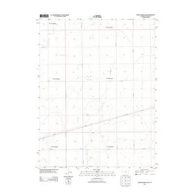
2013 Map of Eureka Creek South
USGS Topo · Published 2013About this map
Eureka Cr and its tributaries define the drainage patterns of this Cheyenne County landscape as it appeared in the early 21st century. The map reveals a strict rectangular survey grid, where gravel and dirt routes like CO Road 25 and CO Road 27 trace section lines across the high plains. This network is bisected diagonally by Us-40 E, a primary transit artery for the region.
Find a feature on this map
21 named features on this map. Tap any name to fly to it.
Don’t see what you’re looking for? This feature index may not catch every label — zoom into the map to look around manually.
Map Details
Editions of this 2013 Eureka Creek South Map
This is the sole edition of this map. No revisions or reprints were ever made.
Other maps of this area

1891 · Kit Carson
USGS Topo · 1:125,000

1893 · Kit Carson
USGS Topo · 1:125,000

1954 · Lamar
USGS Topo · 1:250,000

1958 · Lamar
USGS Topo · 1:250,000

1981 · Cheyenne Wells
USGS Topo · 1:100,000
1982 · Kit Carson
USGS Topo · 1:24,000

1982 · Kit Carson 4 NE
USGS Topo · 1:24,000

1982 · Kit Carson 4 NW
USGS Topo · 1:24,000
1982 · Landsman Hill
USGS Topo · 1:24,000
1982 · Firstview
USGS Topo · 1:24,000