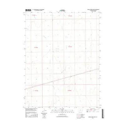
2016 Map of Eureka Creek South
USGS Topo · Published 2016About this map
Eureka Creek defines the drainage pattern of this high plains landscape in eastern Colorado, flowing northward through a series of sections surveyed by the General Land Office. The terrain is marked by the branching paths of Big Spring Cr and Little Spring Cr, which suggest the locations of essential water sources in an otherwise arid environment. The map reflects a structured grid of rural infrastructure, where local transport is governed by the intersection of county routes such as Co Rd R, Co Rd 25, and Co Rd P. This 2016 survey illustrates the persistent ranching and agricultural layout of Cheyenne County, preserving the township and range boundaries of t14s r47w and t15s r48w that have dictated land ownership in the region for generations.
Find a feature on this map
15 named features on this map. Tap any name to fly to it.
Don’t see what you’re looking for? This feature index may not catch every label — zoom into the map to look around manually.
Map Details
Editions of this 2016 Eureka Creek South Map
This is the sole edition of this map. No revisions or reprints were ever made.
Other maps of this area

1891 · Kit Carson
USGS Topo · 1:125,000

1893 · Kit Carson
USGS Topo · 1:125,000

1954 · Lamar
USGS Topo · 1:250,000

1958 · Lamar
USGS Topo · 1:250,000

1981 · Cheyenne Wells
USGS Topo · 1:100,000
1982 · Kit Carson
USGS Topo · 1:24,000

1982 · Kit Carson 4 NE
USGS Topo · 1:24,000

1982 · Kit Carson 4 NW
USGS Topo · 1:24,000
1982 · Landsman Hill
USGS Topo · 1:24,000
1982 · Firstview
USGS Topo · 1:24,000