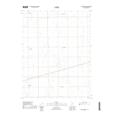
2019 Map of Eureka Creek South
USGS Topo · Published 2019About this map
Eureka Cr and its tributaries define the drainage patterns of this high plains section of Cheyenne County. The landscape is marked by the branching paths of Big Spring Cr and Little Spring Cr, which carve subtle depressions through the dry terrain. This map reveals a strictly organized grid of agricultural and transport corridors, where section lines are followed by local routes such as Co RD 25 and Co RD R. The absence of dense settlements suggests a region dedicated to ranching or dryland farming, with the infrastructure primarily serving the connectivity of dispersed rural holdings. Modern surveyors have documented the township and range divisions here, including portions of t14s r47w and t14s r48w, capturing the precise layout of the county's eastern territory.
Find a feature on this map
15 named features on this map. Tap any name to fly to it.
Don’t see what you’re looking for? This feature index may not catch every label — zoom into the map to look around manually.
Map Details
Editions of this 2019 Eureka Creek South Map
This is the sole edition of this map. No revisions or reprints were ever made.
Other maps of this area

1891 · Kit Carson
USGS Topo · 1:125,000

1893 · Kit Carson
USGS Topo · 1:125,000

1954 · Lamar
USGS Topo · 1:250,000

1958 · Lamar
USGS Topo · 1:250,000

1981 · Cheyenne Wells
USGS Topo · 1:100,000
1982 · Kit Carson
USGS Topo · 1:24,000

1982 · Kit Carson 4 NE
USGS Topo · 1:24,000

1982 · Kit Carson 4 NW
USGS Topo · 1:24,000
1982 · Landsman Hill
USGS Topo · 1:24,000
1982 · Firstview
USGS Topo · 1:24,000