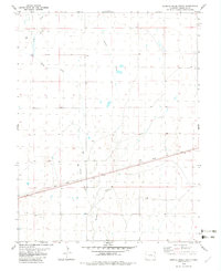
1982 Map of Eureka Creek South
USGS Topo · Published 1982About this map
The Union Pacific railroad cuts a diagonal line across this Cheyenne County landscape, serving as the primary infrastructure for the region's cattle and grain transport during the early 1980s. This High Plains terrain is defined by a series of intermittent watercourses, including Eureka Creek, Big Spring Creek, and Spring Creek, which drain the open range toward the south and east. The map illustrates a strictly organized township and range system, showing the transition between Township 13 South and Township 14 South along the Range 48 and 47 West boundary. This 1982 edition captures the rural character of the Colorado plains before modern agricultural changes, highlighting the critical relationship between the railroad corridor and the natural drainages that shaped local land use.
Find a feature on this map
7 named features on this map. Tap any name to fly to it.
Don’t see what you’re looking for? This feature index may not catch every label — zoom into the map to look around manually.
Map Details
Editions of this 1982 Eureka Creek South Map
This is the sole edition of this map. No revisions or reprints were ever made.
Other maps of this area

1891 · Kit Carson
USGS Topo · 1:125,000

1893 · Kit Carson
USGS Topo · 1:125,000

1954 · Lamar
USGS Topo · 1:250,000

1958 · Lamar
USGS Topo · 1:250,000

1981 · Cheyenne Wells
USGS Topo · 1:100,000
1982 · Kit Carson
USGS Topo · 1:24,000

1982 · Kit Carson 4 NE
USGS Topo · 1:24,000

1982 · Kit Carson 4 NW
USGS Topo · 1:24,000
1982 · Landsman Hill
USGS Topo · 1:24,000
1982 · Firstview
USGS Topo · 1:24,000