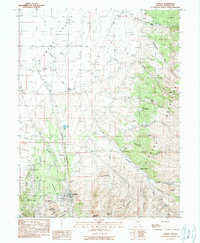
1990 Map of Eureka
USGS Topo · Published 1990About this map
Mining operations and ranching outposts define this interior Nevada landscape at the close of the twentieth century. The town of Eureka serves as the focal point, situated at the base of Caribou Hill and Purple Mountain. The surrounding mountains are heavily marked by the region's industrial heritage, featuring numerous shafts such as the Holly Shaft, Adams Shaft, and the Albion Shaft near Ruby Hill. Evidence of earlier transportation networks persists in the Old Railroad Grade winding through the valley floor west of the Diamond Mountains. To the north and east, the landscape shifts toward a ranching economy with dispersed sites like LaBarry Ranch and Palmer Ranch tucked into canyons. Notable local landmarks including the County Rodeo Ground and the Cem on the outskirts of the main settlement provide specific points of interest for genealogical research or local history studies of this high-desert community.
Find a feature on this map
53 named features on this map. Tap any name to fly to it.
Don’t see what you’re looking for? This feature index may not catch every label — zoom into the map to look around manually.
Map Details
Editions of this 1990 Eureka Map
This is the sole edition of this map. No revisions or reprints were ever made.
Other maps of this area

1926 · Roberts Mountains
USGS Topo · 1:250,000

1929 · Roberts Mountains
USGS Topo · 1:250,000

1953 · Pinto Summit
USGS Topo · 1:62,500

1953 · Eureka
USGS Topo · 1:62,500

1955 · Millett
USGS Topo · 1:250,000

1956 · Bellevue Peak
USGS Topo · 1:62,500

1956 · Whistler Mtn
USGS Topo · 1:62,500

1956 · Ely
USGS Topo · 1:250,000

1959 · Ely
USGS Topo · 1:250,000

1959 · Millett
USGS Topo · 1:250,000