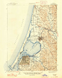
1942 Map of Eureka
USGS Topo · Published 1948About this map
Eureka serves as the focal point for this mid-century survey of the California coast, showing the city's established street grid alongside the industrial waterfront of Arcata Bay. The region's economy is clearly defined by its transportation and resource infrastructure, with the Northwestern Pacific RR and Hammond Lumber Co RR tracing the shoreline and reaching into the timber-rich gulches of the interior. To the north, Arcata is anchored by Humboldt State College, while the surrounding landscape is dotted with rural centers like Fieldbrook and McKinleyville. The map captures a coastal environment defined by transition, from the shifting Sand Dunes of the North Spit to the network of tidal channels including Freshwater Slough and Ryan Slough. Strategic maritime installations, including the Coast Guard Sta and C G Lookout, highlight the importance of navigation at the harbor entrance near South Spit.
Find a feature on this map
96 named features on this map. Tap any name to fly to it.
Don’t see what you’re looking for? This feature index may not catch every label — zoom into the map to look around manually.
Map Details
Editions of this 1942 Eureka Map
3 editions found
Other maps of this area

1916 · Cape Fortunas
USGS Topo · 1:62,500

1922 · Eureka
USGS Topo · 1:62,500

1922 · Korbel
USGS Topo · 1:62,500

1922 · Kneeland
USGS Topo · 1:62,500

1925 · Hoopa
USGS Topo · 1:125,000

1933 · Eureka
USGS Topo · 1:48,000

1942 · Eureka
USGS Topo · 1:62,500

1943 · Ferndale
USGS Topo · 1:62,500

1944 · Fortuna
USGS Topo · 1:62,500

1945 · Trinidad
USGS Topo · 1:62,500