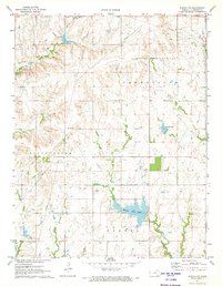
1971 Map of Eureka NE
USGS Topo · Published 1973About this map
Eureka City Lake dominates the southern landscape of this Greenwood County region, serving as a central geographic landmark just north of the city. The area is characterized by the branching drainage of Bachelor Creek, Swing Creek, and the E Br Fall River, where the terrain transitions from open prairie into the more complex, dissected topography of the Flint Hills. In the early 1970s, the local economy was visibly tied to the land, with Oil Wells scattered across the eastern sections and the prominent Thrall Field located to the north.
Find a feature on this map
15 named features on this map. Tap any name to fly to it.
Don’t see what you’re looking for? This feature index may not catch every label — zoom into the map to look around manually.
Map Details
Editions of this 1971 Eureka NE Map
This is the sole edition of this map. No revisions or reprints were ever made.
Other maps of this area

1885 · Eureka
USGS Topo · 1:125,000

1888 · Emporia
USGS Topo · 1:125,000

1888 · Eureka
USGS Topo · 1:125,000

1894 · Emporia
USGS Topo · 1:125,000

1894 · Eureka
USGS Topo · 1:125,000

1955 · Wichita
USGS Topo · 1:250,000

1955 · Hutchinson
USGS Topo · 1:250,000

1958 · Wichita
USGS Topo · 1:250,000

1959 · Hutchinson
USGS Topo · 1:250,000

1967 · Madison SW
USGS Topo · 1:24,000